Coleman McCormick

Archive of posts with tag 'Travel'

August 24, 2024 • #

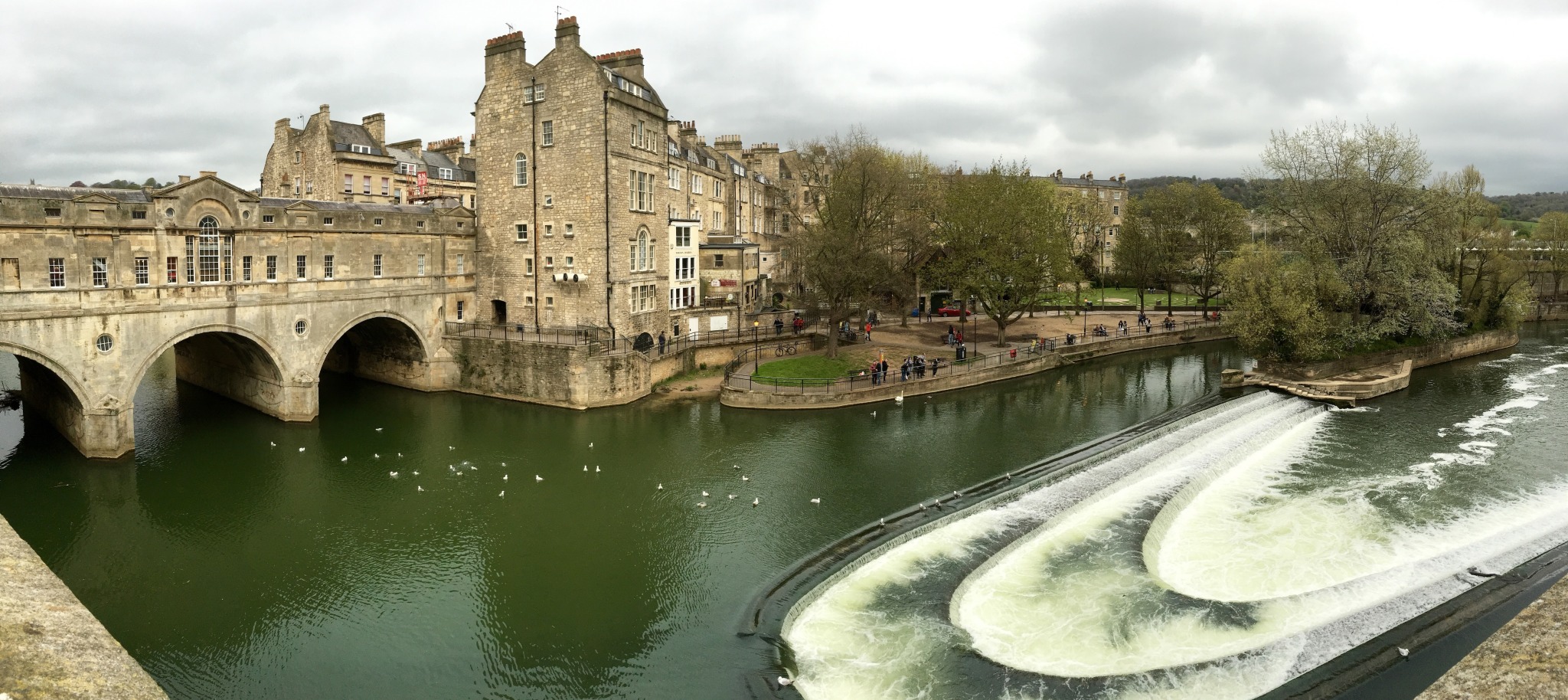
Pulteney Bridge. Bath, England.

April 7, 2024 • #

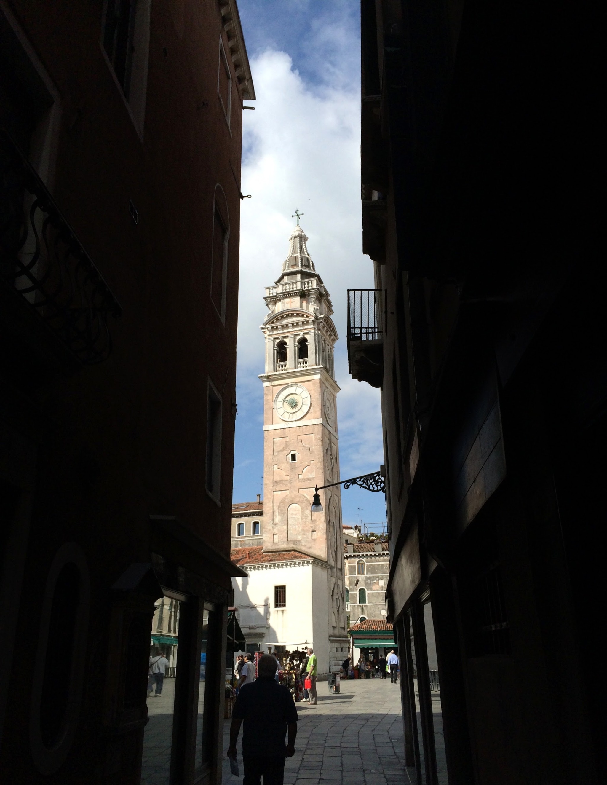
Chiesa di Santa Maria Formosa. Venice, Italy.

April 6, 2024 • #

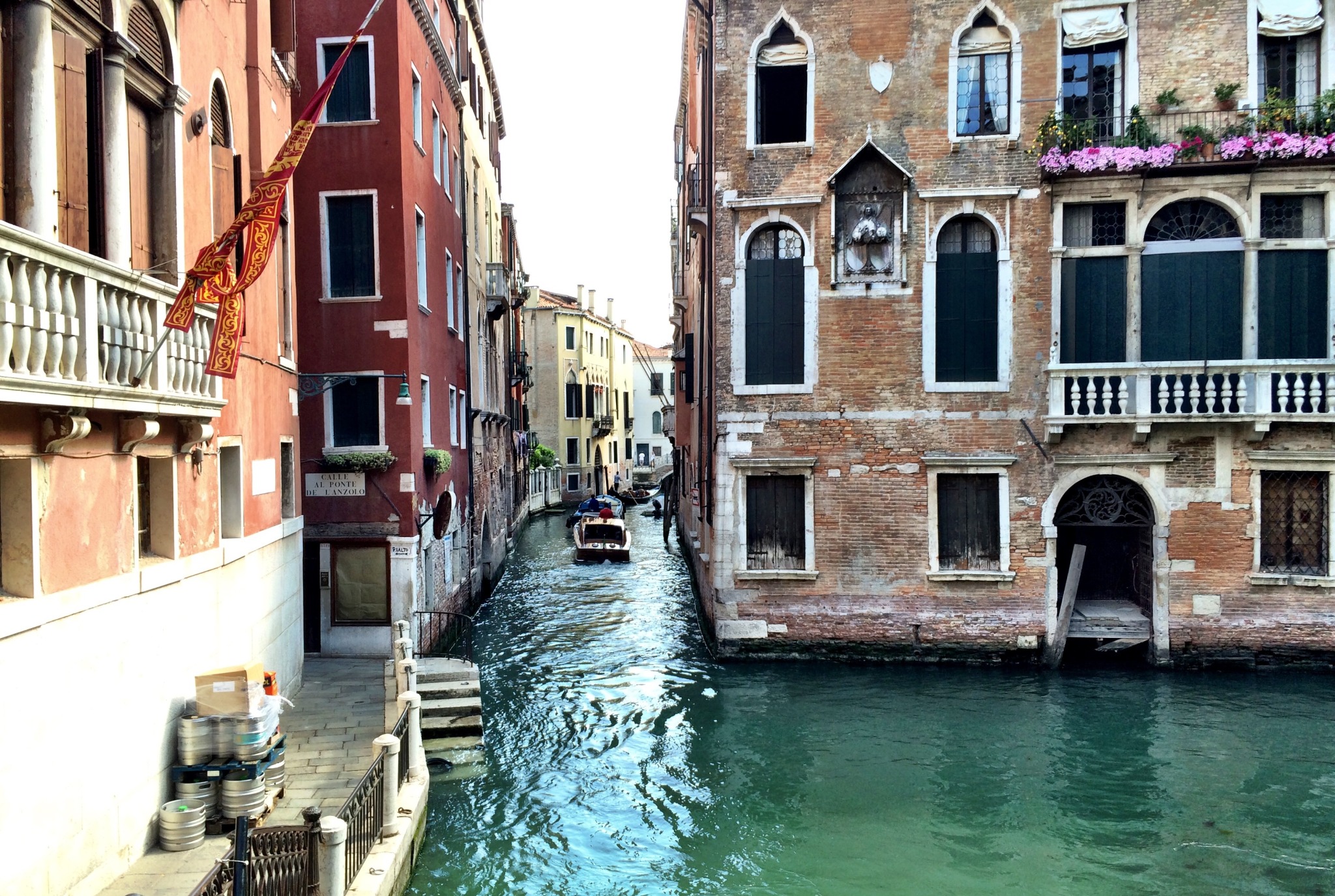
Rio de San Zulian. Venice, Italy.

April 6, 2024 • #

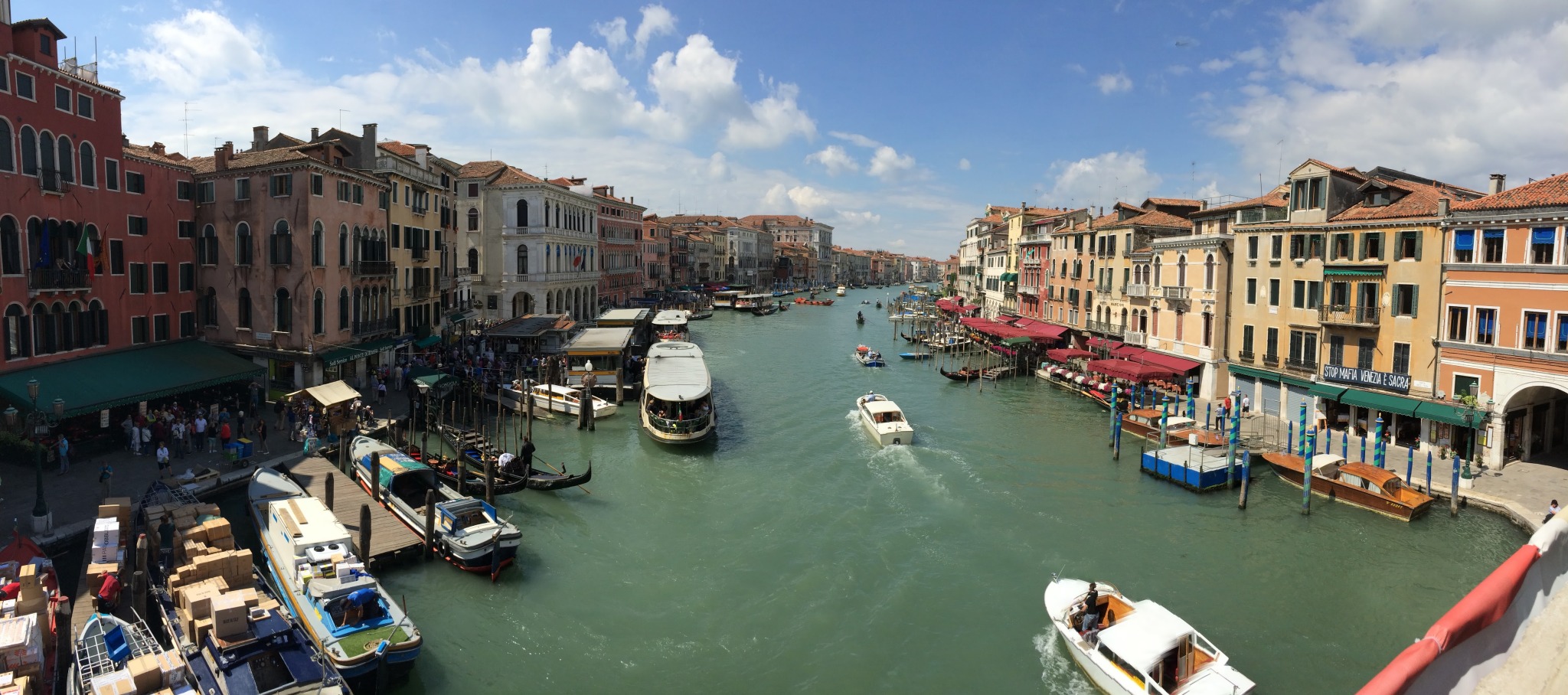
Venice’s Grand Canal. Taken from the Rialto Bridge, 2014.

April 5, 2024 • #

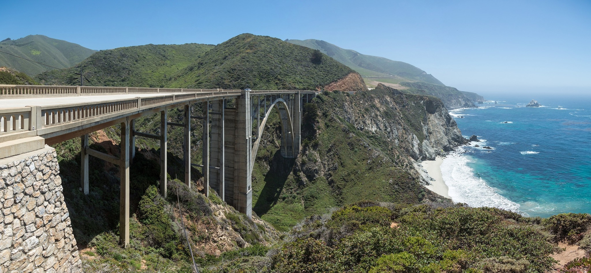
Bixby Creek Bridge. Big Sur, California.

The PCH is a national treasure.

April 5, 2024 • #

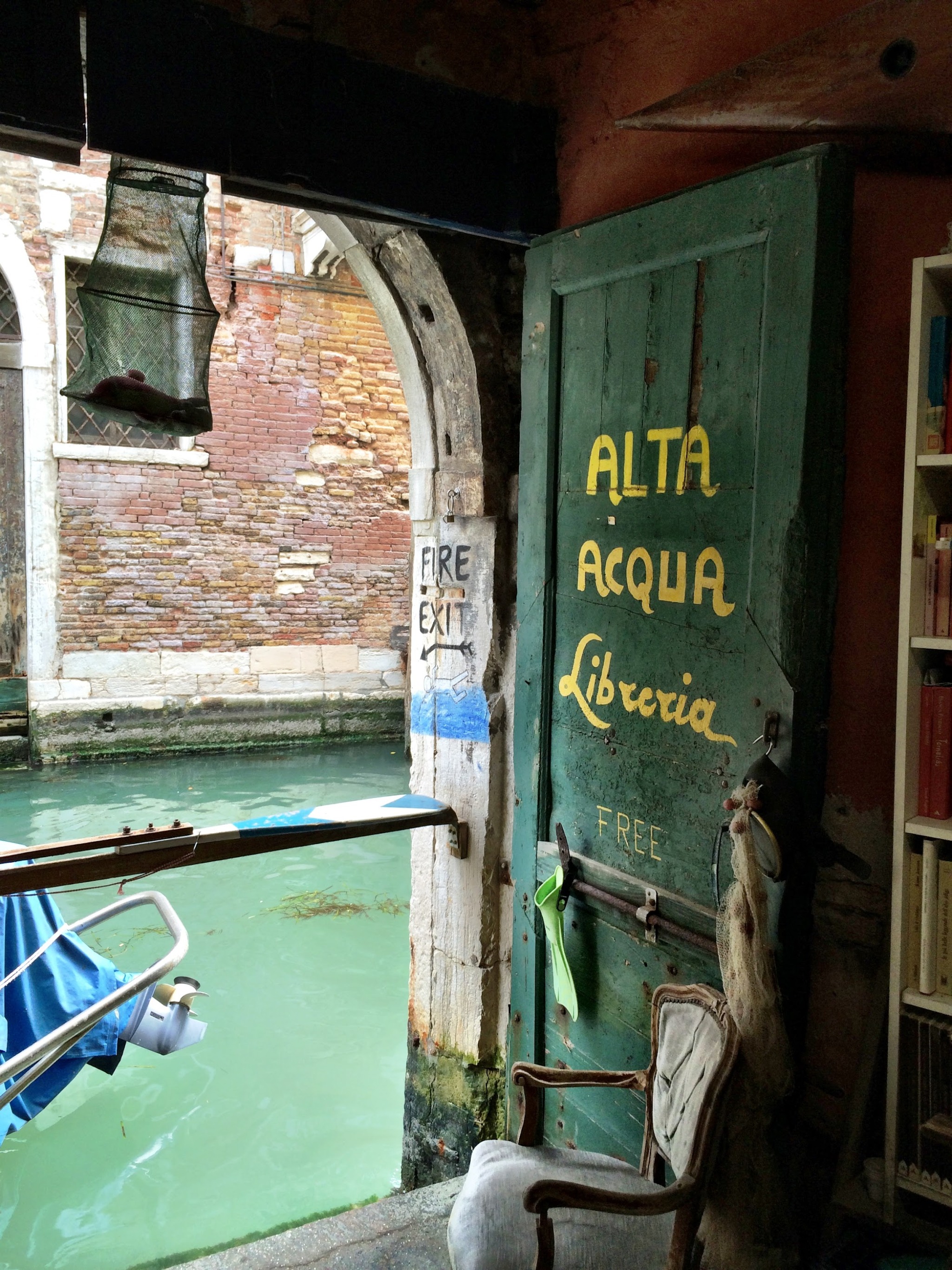
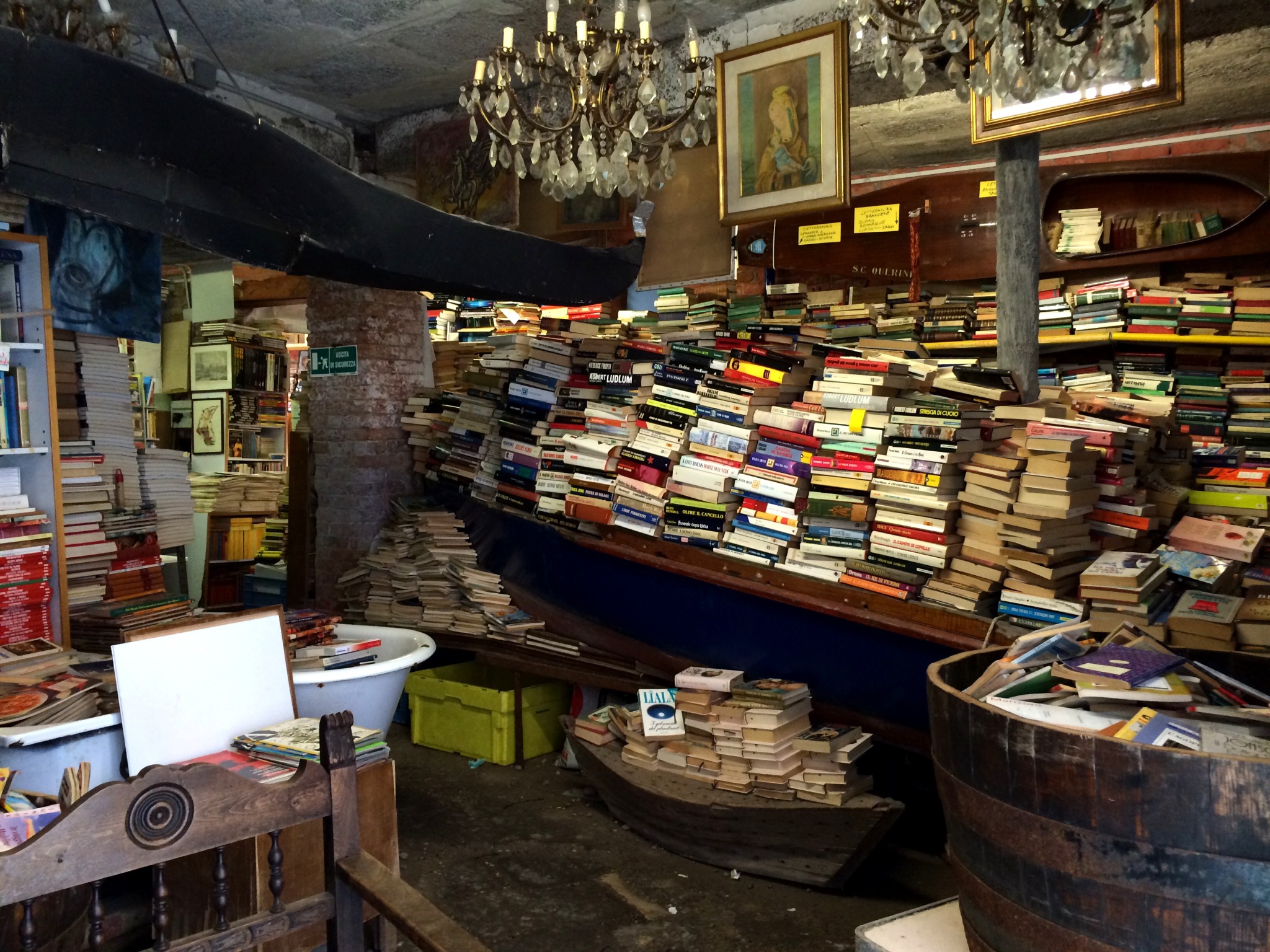
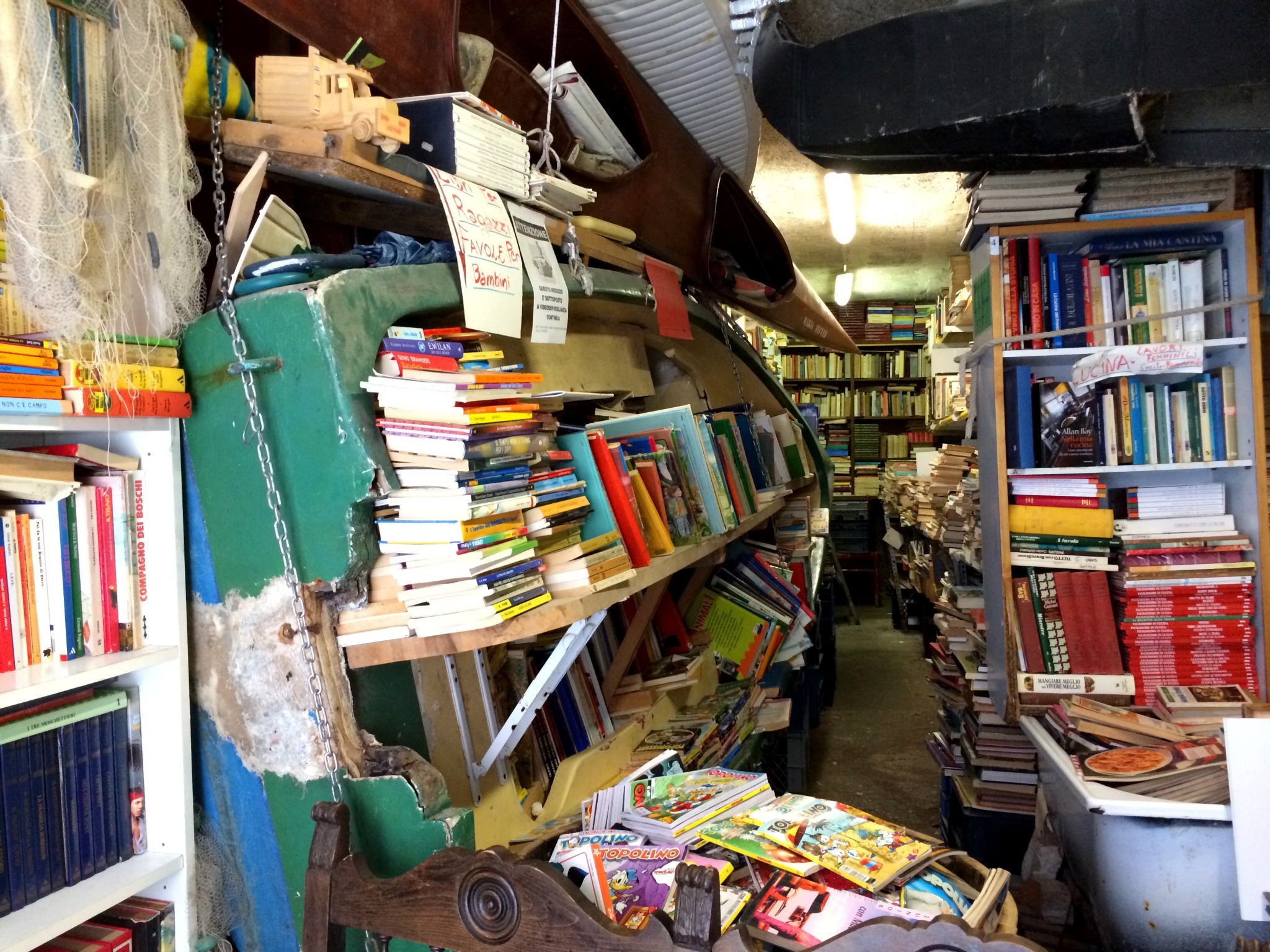
The “fire exit” at Libreria Acqua Alta. Venice, Italy.

Made the trek here in 2014. They keep the books in floating vessels — boats and bathtubs — to keep them safe in when “acqua alta” floods happen.

March 28, 2024 • #

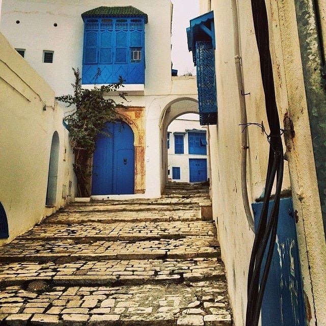
The blue and white architecture of Sidi Bou Said. Tunis, Tunisia.

March 7, 2024 • #

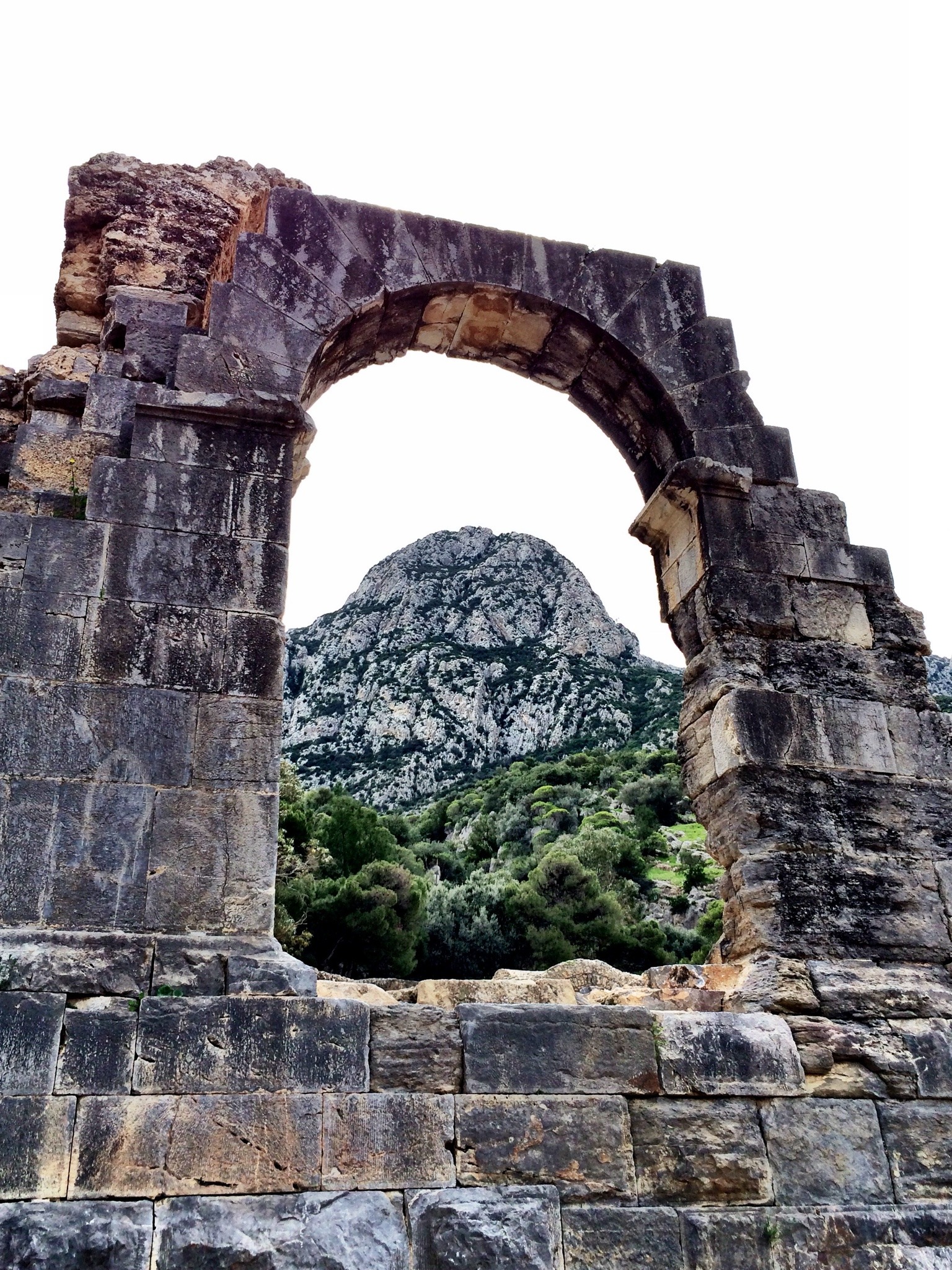
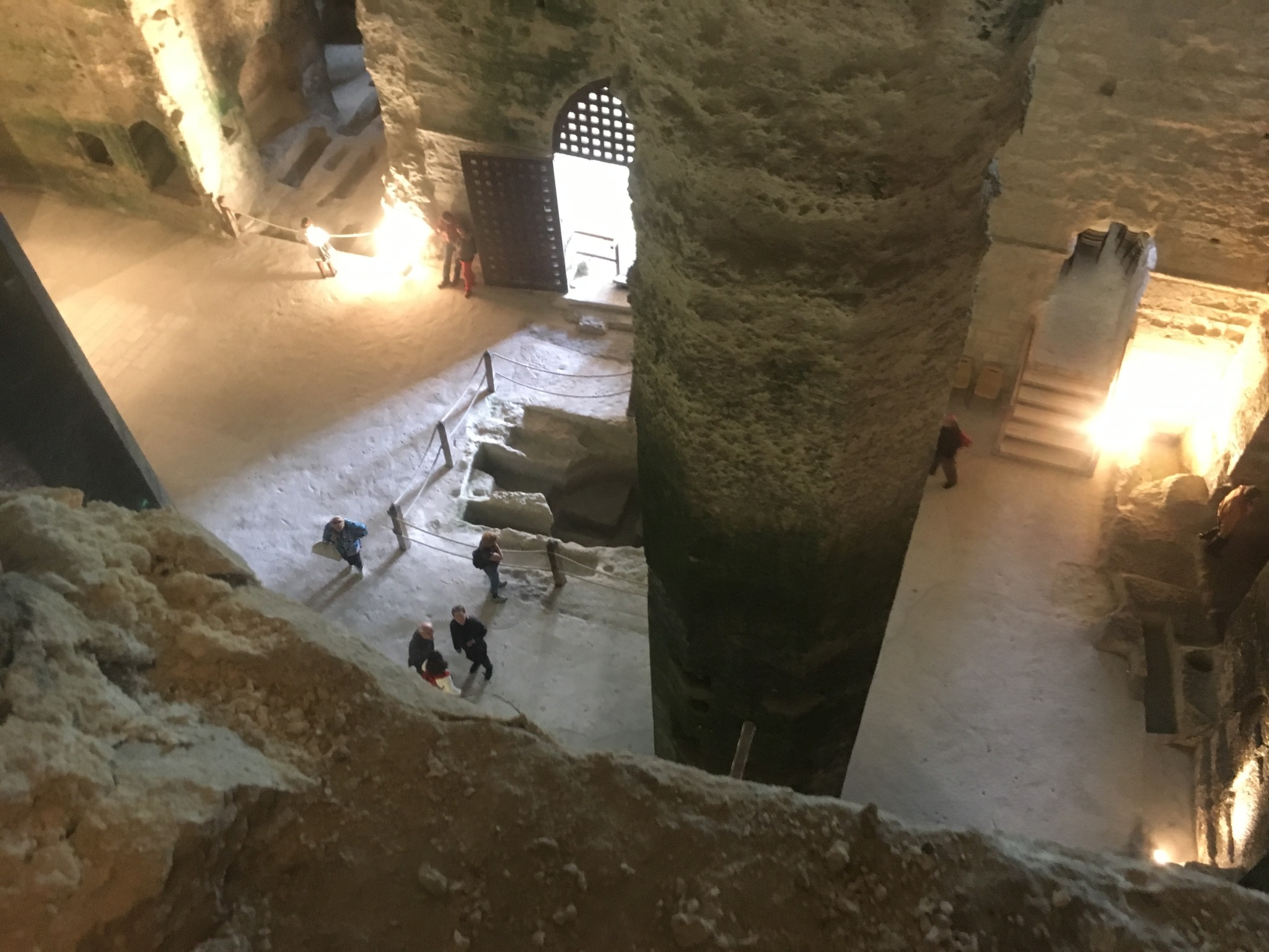
Temple des Eaux. Zaghouan, Tunisia.

Built by the Romans to supply the city of Carthage with water from its sacred spring. Visited in 2014.

February 25, 2024 • #

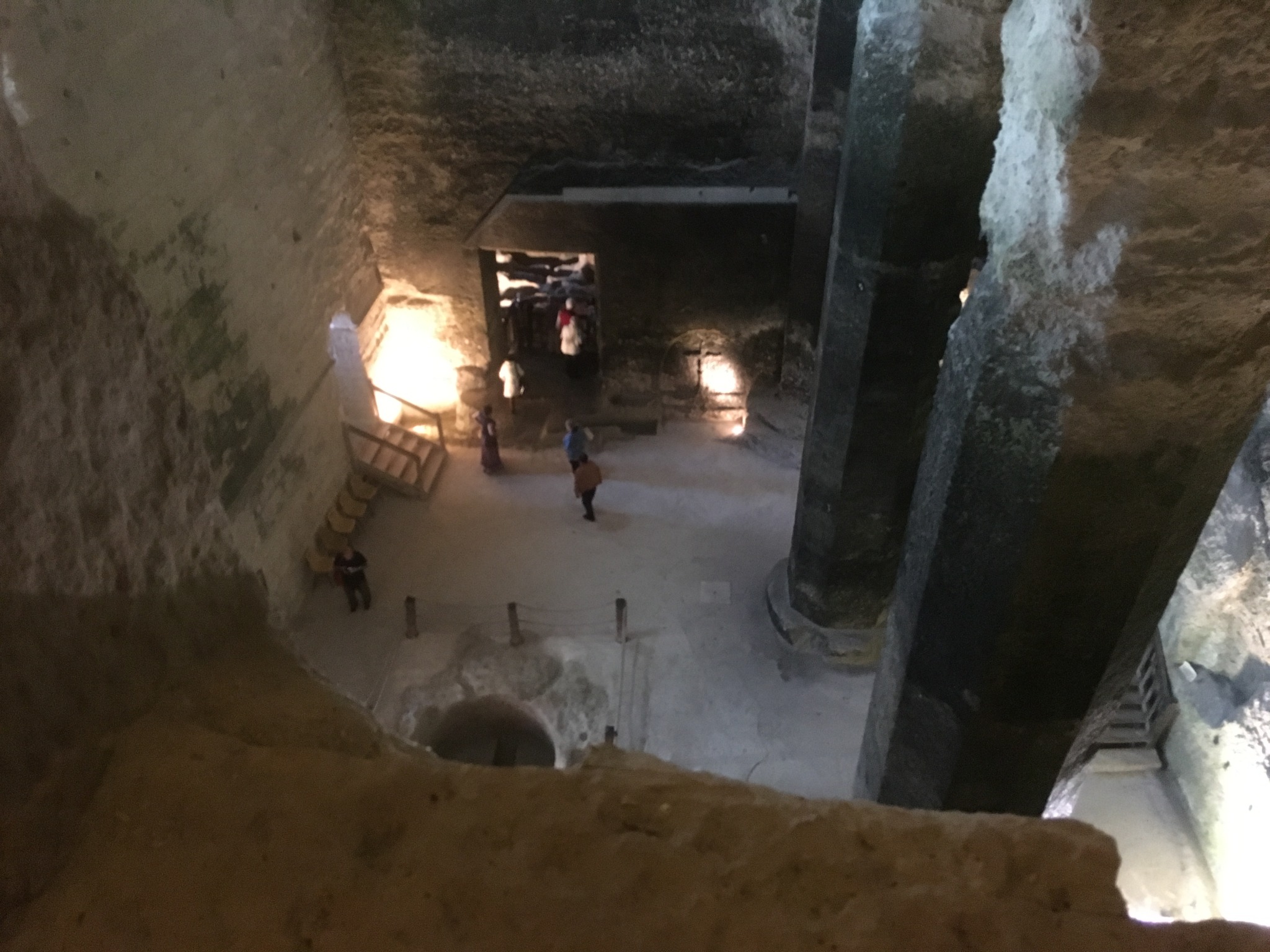
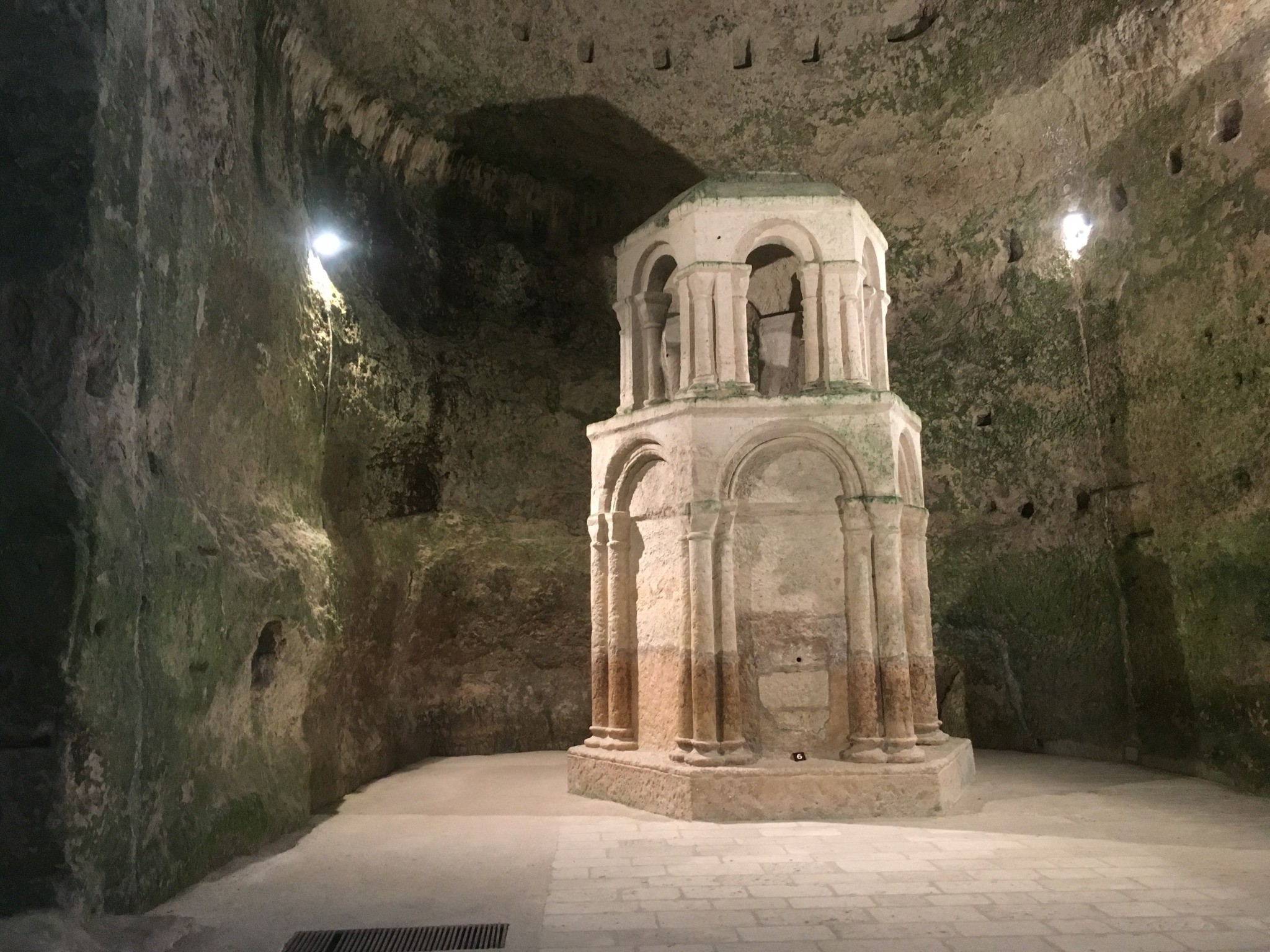
In 2016 we visited Aubeterre in south France. This was inside of the subterranean monolithic Church of Saint-Jean , hollowed out of the mountainside in the 7th century.

January 29, 2024 • #

NearbyWiki: Wikipedia places nearby →

Neat tool for the curious when traveling.

San Francisco

May 22, 2023 • #

I’m out in San Francisco for a few days. We’ve got typical SF weather — big change from the Florida summer suncoast. Got a few meetings to hit, but we’ve got a sailing trip set for Tuesday evening. Hope the weather stays steady.

San Francisco

Denver

April 27, 2023 • #
Denver flatlands

This week I’m in Denver for a couple of days for an event. A little cool weather break from the already-approaching Florida summer. I’m staying out in the flatlands near the airport, and got a chance to get a run in. After the rain quit on day one, day two cleared up and was beautiful to be outside.

Starship Mission to Mars

April 14, 2023 • #

Beautiful and inspiring stuff from SpaceX:

A convincing case for Elon to put his focus all-in on SpaceX, and not 6 other ventures at once.

Summer Trip

August 10, 2021 • #

Last week we did a fun end-of-summer trip across Florida. We procrastinated figuring out a plan for doing something with the kids before school starts back this month.

The kids have never been to any of the famous Central Florida theme parks, so we decided on LEGOLAND in Winter Haven, since it was a bit short notice to do anything at Disney. Everett has been obsessed with the LEGO Mario sets and they both love ‘em, so they had a great time on the rides. The park is great since it’s a combination typical theme park with an attached water park in the back. So we got to do both.

LEGOLAND

After a couple days at an Airbnb in Orlando (which also had its own mini water park), we drove up to St. Augustine for a couple days on the Atlantic beaches. It may seem weird to vacation at the beach when we live 10 minutes from one, but the beaches on Florida’s east coast are pretty different from the west side. The beaches are mostly hard-packed sand, much wider, with more consistent waves than our West Florida variety. I briefly attempted surfing on Elyse’s board, but didn’t come close to standing up.

Then on the last day we circulated through the Castillo de San Marcos fort near downtown, and took a quick walk through the old city before heading back across the state.

Vacation Photos

July 3, 2020 • #

We just wrapped a week on the beach. 10 adults, 10 kids, 3 houses. A few highlights:

Elyse in a banyan tree forest
First night's sunset
Girls outside the house
Breakfast each day looks something like this
AMI sunset 2
AMI sunset 3
Our beach house at night

Vacation

June 26, 2020 • #

Next week us and the local family will be at Anna Maria Island for what is largely a “staycation” — a week at a beach house about 45 minutes from home.

Anna Maria Island

We’ll see how things work with trying to stay semi-quarantined while off-site away from home. The house we’re staying in is right on the beach about 100 feet from the Gulf, with it’s own section of private beach. If we’re properly provisioned, we should be all set to have a relaxing time for the week1. The forecast looks good, all the kids are ready to go.

Only plans so far (if the kids allow): running, reading, kayaking, fishing, cooking.

  1. At least as relaxed as you can get with 10 kids 10 and under tearing around the property. 

Miami

January 22, 2020 • #

We’re in Miami for a couple of days for an event to talk about AI and meet some companies working in the space.

After getting in I was able to fit in a nice run around Brickell Key. Beautiful weather.

Miami Brickell Key

An Island Chain

October 24, 2019 • #

I’m an airplane window seat guy. So when on a flight with good views, I end up gazing out the window for most of the time and capturing my own aerial imagery.

Our Monday flight from Fort Lauderdale to San Juan took us over the Bahamas, so I got some nice scenery to look at during the trip. The first batch was over the centerline of the Bahamian chain, next over Turks and Caicos, then a gap of ocean north of Hispaniola until reaching Puerto Rico.

Here are some of the best shots, with captions for reference.

The Bahamas

Not long after take-off you first see the massive island of Andros on the west side of the island group. It’s land area is greater than all of the other 700 Bahamian islands combined. There are so many islands scattered across a huge area (about the area of Florida) that make up the Bahamas.

Andros Island's north tip, Joulter Cay, and Long Cay
Chub Cay
Chub Cay
New Providence — home to the capital, Nassau
Nassau and Paradise Island
New Providence with Andros in the background
Exuma & Exuma Sound
Exuma & Exuma Sound
Conception Island
Conception Island
Rum Cay
Rum Cay
Mayaguana
Mayaguana

Turks and Caicos

Turks and Caicos is actually a British territory, not its own sovereign nation. I didn’t even remember how close it was to the Bahamas until looking at the map. Most of the people live on Providenciales in the larger Caicos group, and more on the much smaller Grand Turk island.

North Caicos
North Caicos
East Caicos
East Caicos
Grand Turk
Grand Turk

Puerto Rico

An hour or so later we saw the coastline of Puerto Rico, flying right over downtown San Juan on the way in.

San Juan
San Juan

San Juan

October 21, 2019 • #

We’re in San Juan this week for the NetHope Global Summit. Through our partnership with NetHope, a non-profit devoted to bringing technology to disaster relief and humanitarian projects, we’re hosting a hands-on workshop on Fulcrum on Thursday.

NetHope Summit

We’ve already connected with several of the other tech companies in NetHope’s network — Okta, Box, Twilio, and others — leading to some interesting conversations on working together more closely on integrated deployments for humanitarian work.

Fortin San Geronimo de Boqueron

Looking forward to an exciting week, and maybe some exploring of Old San Juan. Took a walk last night out to dinner along the north shore overlooking the Atlantic.

Cape Canaveral

June 23, 2019 • #

We took the kids over to Kennedy Space Center on Saturday on the way up to Jacksonville. A quick stopover in Titusville Friday night then morning over at the Cape.

Rocket Garden

I always loved visiting KSC when I was younger. We had the opportunity to go and see multiple launches over the years, including a couple of Space Shuttle launches. Visiting again brought back memories since they’ve got several things there that haven’t changed much over the years. On the way in you get to walk through the Rocket Garden, which showcases some of the rockets of NASA’s past programs including the Redstone and Atlas rockets from Mercury, the Titan from Gemini, and the Saturn 1B from early Apollo lying prone in the back. Of course the kids loved the chance to sit inside the Mercury capsule.

Kids in Mercury capsule

There’s a new (since my last visit) exhibit called “Journey to Mars” where they’ve got a nice presentation on the past and future of Mars exploration missions. The highlights here were the replicas of Sojourner, Spirit, Opportunity, and Curiosity. It’s amazing in that display to see the increasing size and complexity of robotics we’ve been able to successfully land and use on Mars. Makes you wonder what we’ll do next.

Curiosity Rover

One of the other classics from when we used to visit as kids is the astronaut memorial. There’s nothing terribly spectacular about it, but it’s an important reminder of the sacrifices made throughout the nation’s research, experimentation, and launch attempts to explore space. We had to go check this out for nostalgia’s sake. I still find it impressive and it reminds me of the times when our manned space program was active and astronauts were like mini celebrities.

Astronaut memorial

The last part we checked out was the new Space Shuttle exhibit with the old Atlantis orbiter on display. It reminded me of how advanced the shuttle really was for its time, as a technology of the early 80s, and also how large the orbiters were. In hindsight the whole thing seemed pretty impractical, but the set of dozens of exhibits serve as a reminder of all the amazing things that were enabled by routine trips to orbit by the Space Shuttle. It was cool to get to stand up close to something that went into space 33 times.

Space Shuttle Atlantis

For our next visit I’d love to go out to the Saturn V exhibit, to which you have to take a bus tour. Maybe it’d be a better time then for the kids to get out on the deeper tour that takes you to the VAB and the launch pads. I always loved getting to see that stuff.

The Deadly Logistics of Everest

May 3, 2019 • #

Earlier this week I finished reading Jon Krakauer’s Into Thin Air, his account of climbing Mount Everest and surviving the 1996 Everest disaster. The book reads like a thriller, giving the account of how an expedition team prepares for the climb, including the experience in country beforehand and acclimatization process for weeks leading up to the climb.

While reading it, I found myself wishing I had the visual aid of maps of the route, photos of the camps, and what certain of the landmarks (like the dangerous Khumbu Icefall) actually look like. This video gives a good sense of the monumental scale of the challenge of climbing the 29,000’ peak.

Notre Dame

April 17, 2019 • #

The news of the fire at Notre Dame in Paris was devastating to follow along with as the blaze continued to spread throughout the day on Monday of this week. Many people from the office and on Twitter were reminiscing about their own visits there in the past, which got me looking back at old photos of mine.

The Flying Buttresses of Notre Dame

We visited Paris twice, once together on a tour in 2014 and again when Elyse was little in 2016. Both times we took walks down the Seine to Ile de la Cite. When the weather’s good in Parisian summer, the walk along the river and the site itself on the island are incredible.

The iconic towers on the front are enormous and ornate for an old structure, but my favorite pieces of architecture are the flying buttresses visible from the courtyard area, and the eroded gargoyles studding the sides.

Gargoyles & Spire

I’m fortunate to have seen it multiple times. It’s a truly amazing structure in a beautiful city. Disasters like this week’s fire are an eye-opener to how fragile many of our historic sites and artifacts are. A run-of-the-mill electrical fire can undo so much history. The silver lining is that the firefighters on the scene were able to save it from total destruction.

Elyse with the Towers

San Diego April 2019

April 15, 2019 • #

I’m here in San Diego for the week for the FOSS4G North America conference. Today there was a “B2B / Government” focus day, hosted at the Mission Bay Marina Conference Center, a gorgeous spot right on the waterfront.

We’re staying at the Hyatt in Mission Bay. I got in a nice run out to Mission Beach, which is easy to fit in with the weather and views available along the route.

Over the Bay
Over the Bay
Mission Beach
Mission Beach

FOSS4G North America 2019

April 11, 2019 • #

Next week Joe and I will be out in San Diego for FOSS4G-NA 2019. This’ll be my first one since I think 2012. There’s always an excellent turnout and strong base of good folks to catch up with. This year they’ve put together a B2B and Government Theme day to kick it off, which to my knowledge is a new thing for an event typically focused on the eponymous free, open source, and community-driven projects.

FOSS4G-NA 2019

I thumbed through the agenda to pick out some topics I’m interested in catching this year:

  • Open source for utilities and telecom
  • OpenStreetMap and WikiData
  • Open source in higher education
  • PDAL
  • OpenDroneMap
  • Digital twin” technology for infrastructure

A Drive Through Central Florida

March 19, 2019 • #

We just got back this evening from a long weekend trip up to Jacksonville for medical follow-up and to visit with friends. It’s about a 4 hour drive from St. Pete, and I usually do a route that takes us up I-75 to around Ocala, then connect up to I-10 up US-301. Then the same route home in reverse.

The trip down 301 takes you through a half dozen tiny to small towns that are quintessential “Old Florida”1. On this drive down I thought I’d briefly document each of them with a photolog of sorts, for anyone unfamiliar with what rural Central Florida looks like.

In order from north to south as you connect between the interstates, you pass through:

  • Lawtey
  • Starke
  • Waldo
  • Orange Heights
  • Hawthorne
  • Citra
Lawtey is the first town you pass, it takes about 30 seconds to traverse from north to south
Grannie's is a famous stop in Starke, one day we'll stop for a full-service lunch
The Waldo Flea Market is a staple, we used to make trips there from Gainesville in college
Hawthorne is a frequent fuelling stop, for the Buick and the kids
When you pass Citra's Orange Shop, you know you're about 10 miles out from 75

As you can tell, these are some small places. It’s always a reality check to see how relatively sparsely populated so much of the state is, and how different it is living even a couple hours from a major city.

  1. A few of them are also notorious as speed traps, with speed limits dropping from 65 to 35 over a quarter mile through them. 

Sierra Nevada, Basin and Range

February 8, 2019 • #

One of the highlights of the west → east flight from Northern California is the chance to get views over the ranges of California, Nevada, and Colorado. The first leg of my flight home this week took me from San Jose to Denver, offering up those snow-capped mountains I so rarely get to see living in the southeast.

Sierra Nevada

Not too far into the flight you come upon the Sierra Nevada, if you’re lucky passing right over the Yosemite Valley. Today there was a thin, low cloud layer over the mountains, so the view wasn’t perfectly clear, but I caught pretty great views of the peaks and notches of the high Sierras.

Basin and range

The folds of the basin and range province as you pass over Nevada are some of my favorite landforms to check out from the air — 500 miles of alternating faulted mountains and flatlands.

The Salton Sea

February 6, 2019 • #

I don’t remember what got me to it, but the other day I found this short documetary video about Southern California’s Salton Sea, a saline lake about 80 miles inland from San Diego:

I knew about its infamy as a failed resort destination, with planned developments like Desert Shores and Salton City that popped up on its edge in the 1950s. What I didn’t know was the sea’s history as the result of an engineering accident, induced by the California Development Company trying to divert the Colorado for irrigation purposes, back in 1905. That accident, high rains and snowmelt, and subsequent attempts to control the high waters resulted in the basin filling up. The geothermal activity in the valley gave the lake a salty, sulfurous quality that since ruined its chances as a vacation attraction.

The Salton Sea

On this week’s flight into LAX, I got to see the lake from the air. It’s an eerie thing to see the bones of little towns scattered along its shores. Even from 30,000 feet you can see the murkiness of the water. From this perspective, it’s amazing to think that the developers of the mid 20th century thought there was promise here.

Kicking Off SaaStr

February 5, 2019 • #
SaaStr 2019

Today was day 1 of the 3-day SaaStr Annual, my third one. Each year they up their game in terms of size and session quality. Logistics are much improved at the larger San Jose Convention Center. The team at SaaStr did an excellent job improving on the shortcomings of past years while still expanding in attendance quite a bit.

I did sessions today from Tom Tunguz from Redpoint, Ryan Smith of Qualtrics, and a great back-and-forth discussion with Jeff Lawson (Twilio) and Anil Dash (Glitch).

San Jose

February 4, 2019 • #

We just touched down in San Jose this afternoon, here for the SaaStr Annual conference. An uneventful flight through LAX, arriving around 1pm local time here in California. One of my favorite things about westbound travel is the ability to get here with enough time to check things out the same day.

San Jose, California

As I like to do with a new city, I got out on the road for a run to explore a little. The Guadalupe River runs through downtown San Jose right near where I’m staying. Even though the weather was not playing nice, there was a clear spell before sunset so I decided to get a couple miles in and check things out.

Guadalupe River

The river was just about to bust over the bank, with the rain rushing northward toward San Francisco Bay. The cold and my lack of preparation for a wet run cut me a little short, but it was nice to get the opportunity right when I got here. If one of the mornings in the next couple days yields nice weather, I’ll be out there for sure.

Energy & Geography in 2050

November 16, 2018 • #

Another great Geography2050 is in the books. This year’s focus was on energy, and as you might expect much of the panel discussion and subject matter expertise was on renewable energy sources and climate change response issues. It’s a topic I follow loosely, but I learned a lot about the diversity of organizations working on the problem and heard a number of interesting new ideas.

Low Memorial Library

One of the best panel discussions was on energy consumption and economic growth in China — nearly an hour and a half discussion on how China got where it is today, and what the political atmosphere is like around addressing renewable energy issues.

The whole AGS crew, the Council, and all of the sponsors did a phenomenal job bringing it all together (as usual!).

Next year’s focus topic will be on borders — that one should yield some fantastic discussion.

New York City

November 13, 2018 • #

Every year we make the trek to New York City for the annual Geography 2050 conference, the pillar event organized and hosted by the American Geographical Society. We’re staying in Times Square and the event is uptown at Columbia University, with day 2 hosted at the incredible Low Memorial Library.

Times Square

After a nice 2 hour delay this morning I finally made it into town. Picked a good seat with the approach into LaGuardia past lower Manhattan. This is always a window seat flight for me, with the chance to get a good view of the City from above (weather and luck-of-the-draw permitting).

Lower Manhattan

It’s going to be a chilly week up here, with weather getting down into the 30s over the next couple of days. We’ll be close enough to the lower end of Central Park that I’ve got a couple of runs planned. Going to have to do pick up the pace if I want to stay warm.

Fenway Park

October 22, 2018 • #

A few weeks back I had an opportunity to catch a game at Fenway Park for the first time. That’s definitely a bucket list item checked off.

Fenway Park

Tim got tickets last minute, some great seats down past the bend on the third base side, beneath the Monster. It was a beautiful night, with Chris Sale on the mound against the Blue Jays.

Recent Links: Playing with Numbers, Logistics Networks, Vancouver Island

September 13, 2017 • #

🎓 Numbers at Play: Dynamic Toys Make the Invisible Visible

Great tools keep up with their users. They operate at the speed of thought, ever shrinking the feedback loop between conceiving of an idea and exploring its consequences.

Tools for thought must support communication not just from the expert to the novice: they should enhance conversation between collaborative peers. They should enact thought at the speed of speech. With tools this fluid, we can reinforce natural dialogue through novel representations without awkward pauses. We can support students in co-constructing meaning as they discuss and resolve their multiple interpretations.

Fascinating work by the Khan Academy research team. They’re exploring different types of tools for teaching using visible, tangible “toys” to visualize concepts like fractions, subtraction, and more with interactive models.

🚢 How Logistics Networks Respond to Natural Disasters

I just finished up reading The Box, a history of how container shipping came about and evolved the global economy. With the storms of the last few weeks, I always wonder what sorts of second- and third-order impacts there are around the world when supply chains are disrupted by natural events.

🇨🇦 The Wild West Coast of Vancouver Island

I enjoyed this piece in Cruising World about a family’s sailing trip down the west side of Vancouver Island. The wild, wooded, and rocky coast of British Columbia is amazing landscape. They took this trip with their daughters of 2 and 5. What an amazing experience for kids to see wild bears and the village outposts in those harbors.

Amicalola and Dahlonega

December 5, 2015 • #

Since we never get out and about much on trips up to Atlanta, this time we took a trip out to Amicalola Falls up in the North Georgia mountains, near Dawsonville. I forget where I started googling around looking at waterfalls in GA, but probably something in the book I’m currently reading got me looking around for outdoorsy things to do while we were up there.

Amicalola Falls

The falls are actually the tallest of all the waterfalls in Georgia, with a 729-foot drop!

The drive out was about an hour and fifteen minutes, so it’s easy to get up there for a day trip from Atlanta. We got there about noon, with completely clear skies and gorgeous weather in the mid- to upper-fifties. Couldn’t have asked for anything better. We first started off checking out the visitors’ center real quick to get a map and see what they had, then we drove to the base where there’s a reflecting pool, as well as the Appalachian trailheads. We hiked up probably halfway, where there’s a footbridge to walk over. That first half grade isn’t too steep, but after that point it goes almost vertical and it’s all stairs on the wooden boardwalks they’ve constructed ascending the face of the mountain. We opted not to do the hike all the way up, mostly since that would mean having to do the descent, too. I was wearing Elyse in her carrier, and that’s actually worse (and somewhat dangerous) to walk down the treacherous stairs with low visibility over her, plus the weak knees after a while. We drove up to the summit and looked out over the valley — gorgeous view.

Vertical Flume

After leaving Amicalola, we drove over to Dahlonega just to stop in the downtown area and see what was up during the holiday season. It was super busy around the town square, and we didn’t do much but grab some coffees, walk around the block, and pop back into the van for the drive back into town. Elyse sat with her first Santa!

Tunisia

June 7, 2014 • #

I recently took a trip to Tunis to attend the GCT-Tunisia conference, a geospatial industry event focused on capacity building and promotion of mapping tools in the fluid and exciting region of North Africa. It was a fascinating trip to visit a place at such a turning point in its development. Both Tunisia and Libya, each of which had significant representation at the conference, are still just 3 years out from revolutions that unseated regimes in power for decades. It was a welcome opportunity to visit during this period of transition (yet relative safety and stability).

Tunis Carthage Airport

Traveling from Florida to North Africa is a trek. We flew through JFK Airport in New York, to Atatürk Airport in Istanbul, then onto Tunis-Carthage. For the international legs we flew on Turkish Airlines, which was a first for me. Turkish didn’t have the luxury-by-default feeling of the Gulf airlines, but it was comfortable. And for being an international hub and one of the busiest airports in the world, Atatürk was easy enough to transit between gates and move through security. Even at 5am local time, the airport was a swarm, with a varied crowd that proved Istanbul really is “where east meets west”.

The flight to Tunis left early in the morning local time. There were some fantastic views of the Greek islands and Sicily’s Mount Etna from my window seat. Tunis-Carthage Airport is right in the geographic center of the city. From the east, you fly in right over the Lake of Tunis, a natural lagoon encircled by the city. Passport control was slow, but easy, and the terminal was bustling with people. We caught a car ride to our hotel - about a 20km drive through La Marsa up along the beach to Gammarth. For a city that underwent a revolution only 3 years ago, there are few visible signs. We heard from some of the locals that before and during the revolution, much of the European expat population left the country, but things seem to be recovering strongly. Our hotel and the neighboring ones on the waterfront were crowded all week with people from Europe and all over the region.

Sidi Bou Saïd

Early in the trip we visited the old town of Sidi Bou Saïd, which is a fascinating hilltop settlement and tourist spot with amazing views overlooking the Mediterranean. It’s packed with shops selling mostly artwork — paintings, pots, dishware, and the like. Since it’s positioned on the center of a bluff above the waterfront, it has labyrinthine streets winding between distinctive white and blue buildings. We didn’t do much here but buy some gifts for those back home, then eat some pizza at a nearby local joint.

The highlight of the trip was toward the end of the week, when the conference organizers put together an excursion tour that took us south to a town called Zaghouan, to visit an ancient Roman water temple at the base of the mountain. We hopped into a tour van early on Friday to make the journey into the countryside to Zaghouan, which gave Patrick and I ample opportunity to snap photos from the road (for some post-trip OpenStreetMapping). On the way out of town we stopped near the ruins of Carthage to see the destination of a 3000 year old aqueduct that once led to the cisterns where the Romans stored and supplied the city with water from the mountainous south. About 30 km south of Tunis we stopped on the roadside to see the remnants of the aqueduct, at a point where it’s remarkably well-preserved. It feels unbelievable to stand beneath a structure nearly 2000 years old and marvel at the fact that even this form of ancient plumbing is still standing. There are even sections of it where the original water pipeline is still covered and intact.

Djebel Zaghouan

Another hour or so of driving took us into the city of Zaghouan, which sits beneath Djebel Zaghouan, a craggy mountain that’s one of the northernmost peaks in the Atlas range. We wound our way up the streets into the foothills, to the “Temple des Eaux”, the Roman water temple. The Romans built the temple on top of a spring in the second century AD - it served as a place of worship, and the source of the aqueduct that supplied water to Carthage via the aqueduct. You could see the pipe where water was siphoned from the spring emerging from the side of the hill, where it slowly pitched downward onto the top of the aqueduct for its 100km downhill trickle. The views from the temple are incredible. The climate and topography make it feel like you’re in southern California, overlooking the olive orchards and almond plantations of the surrounding area. With our fellow geographers out in the field, everyone naturally couldn’t help but do some surveying while on site at such a historic place. One of our tour-mates, a surveyor that builds and operates 3D laser scanners, broke out the devices to gather some high-resolution scans of the temple site.

El Fahs

About 20km west of Zaghouan is the smaller town of El Fahs. There we were visiting the ruins of a Roman city called Thuburbo Majus. On a hilltop a few kilometers from the main town, it’s quiet, calm, and stunningly well-preserved and protected. We arrived there in the mid-afternoon to an empty site. There were two staff guards at the entrance that let us in, then we pretty much had the entire site to ourselves. The road through the site dates from nearly 2,000 years ago, and various of the structures were built over the next 3 or 4 centuries. The highlight of the walk through the ruins, for me, was an archway between the baths and an elevated temple, dating from the time of the Punic Wars — narrow, perfectly constructed, and still standing after 20 centuries. Completely unbelievable, and at a site with relatively little oversight or protection. I could touch the arch when walking beneath it.

Punic arch

Up on the site of the old forum, some local boys were kicking the football around. I overheard an argument about who was “Cristiano” as they were chasing the ball up and down the stairs to the columns of the capital.

Soccer on the forum

The wildflowers were so dense we could barely walk through them. I got some video walking through the “House of the Auriga” and the Winter Baths. A stunning place to get to visit, with beautiful weather the whole day of our excursion.

I’ve posted a bunch of photos from Tunis and the excursion up on Flickr.

Cabbage Key

October 9, 2013 • #
Egret

I spent last weekend with the family at Cabbage Key, an island near Charlotte Harbor, in southwest Florida. It’s only visitable by boat, so we launched the Shamrock on Friday morning to head over to the cottage, including a number of cargo trips to bring all the weekend’s people and provisions.

We had a fantastic time fishing, sailing, drinking beers, and eating. Cabbage is a great spot that’s close enough to drive to, yet still detached enough to feel like a true vacation away from home.

House on Cayo Costa

On Saturday we visited a friend’s rustic cabin on Cayo Costa, a barrier island state park, with a mangrove-lined shore on Pine Island Sound, and a beach on the Gulf. Since, like Cabbage, Cayo Costa is only accessible by private boat or ferry, it’s pretty secluded. Our family friend’s cabin is a minimalist setup, with just enough shelter, a generator, and small kitchen — perfect for our weekend seafood grill session.

I recorded some GPS traces of a few of our outings, a couple on the Shamrock, and some aboard Nat’s 18’ Buccaneer. We had an amazing sail back to Pineland on Monday (the red line below), averaged 6 knots in rough seas, making the 5 mile trip in a little over 45 minutes. We had the tails of Tropical Storm Karen sweeping through that afternoon, so we made it back just ahead of a heavy squall.

It was convenient on the trips to have the charts readily-available offline in Fulcrum. Once I figured out how to download the raster data, convert it, and load it in, it was pretty simple. I now have a process for doing this with any of the digital charts that NOAA publishes. I had built a small app in Fulcrum for reporting errors on the charts, and used it with some success out on the water. Though I’m not sure what exactly constitutes an actual missing feature, what things are “managed” as canonical features for navigational charts, and how to report them back. Planning a future post on this soon.

In all the hacking I’ve done with charts and data in recent weeks, a small side project is coming together to make it easier to extract the raw data from the electronic charts, not just rasters. NOAA’s formats are workable (and supported in GDAL), but it’s far too difficult for a regular person to make use of the data outside the paper charts or expensive proprietary chart plotters. A project is brewing to do more with that data, to make it more consumable and ready for mapping out-of-the-box, so stay tuned.

Preparing for Kayaks and Scalloping in Weeki Wachee

August 21, 2012 • #

We’re headed to Weeki Wachee this weekend to do some scalloping, kayaking, and diving. We’ll be hanging out up at the springs and (hopefully) catching our limit in bay scallops out on the sea grass. On Sunday I was up in Dunedin helping my dad get the engine ready to put back in his boat. He’s got a Shamrock, and has been putting together a new Chevy 350 to install before we head up for the weekend. There was a little fiberglass work that needed doing on the center console, too, to shore it up from water damage.

Fiberglassing

I’ve built several apps in Fulcrum for capturing different sorts of data while we’re out and about: for bird sighting locations, one for marking scalloping spots, and another for aids to navigation and other marine features for eventual contribution as OpenSeaMap features, and I also built a catchall for capturing “geonotes”, blobs of text with a photo for some general comment. Can’t wait to do some real field collection.

Weeki Wachee River

I pulled down some DOQQs from Florida’s LABINS site, built some nice high-resolution offline maps with TileMill, and downloaded them to my phone in Fulcrum. There are tons of creeks and canals running through the wetlands near the mouth of the Weeki Wachee River, and I’ll be able to catalog which ones are navigable by kayak at high or low tide.